Services set to shut down as 'super typhoon' heads for South China
This story will be updated as the situation unfolds. China is bracing for the arrival ...

UPS: CLOSING DEALSGXO: LOOKING FOR VALUEXOM: LNG PARTNERSHIPXPO: UNDER PRESSUREDSV: GAUGING UPSIDEAAPL: 'NOT ENOUGH'AAPL: SMART RACELINE: NEW LOW AMZN: NEW INVESTMENTEXPD: 'NO-LAYOFF POLICY' EXPD: LEGAL RISK FWRD: REACTIONWTC: BOLT-ON DEALDSV: BLACKROCK HOLDING UPDATEAMZN: TOP PICK
UPS: CLOSING DEALSGXO: LOOKING FOR VALUEXOM: LNG PARTNERSHIPXPO: UNDER PRESSUREDSV: GAUGING UPSIDEAAPL: 'NOT ENOUGH'AAPL: SMART RACELINE: NEW LOW AMZN: NEW INVESTMENTEXPD: 'NO-LAYOFF POLICY' EXPD: LEGAL RISK FWRD: REACTIONWTC: BOLT-ON DEALDSV: BLACKROCK HOLDING UPDATEAMZN: TOP PICK
Hurricane Milton will hit Florida tonight, amid highways jammed with evacuating families, National Guard deployment, grounded cargo and passenger planes – and what could be a second tropical storm forming to the east of the state.
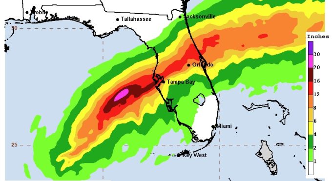
The hurricane, currently a category 5 but expected to be category 4 by the time it makes landfall, is around 300nm away from Tampa, and is expected to make landfall late tonight or early tomorrow.
A storm surge of as much as 15 feet is set to engulf Tampa Bay, where densely packed suburban-themed residences sit on islands of reclaimed land barely above sea level.
A warning by the US Coast Guard shortly after 7am EDT (12pm GMT) warned of wind speeds of 105 knots, and ordered shipping and flights in the area to alter course.
Three Orlando airports closed yesterday, along with Tampa International Airport, a decision “not made lightly” in the face of thousands of residents attempting to get flights out of the state. Airlines increased the cost of tickets for flights leaving Florida to $1500 and more yesterday, prompting president Joe Biden to demand “…as much service as possible to accommodate evacuations,” and “not to engage in price gouging — to just do it on the level”.
Still recovering from the the effect of last week’s east coast strikes, ports along Florida’s western seaboard are making preparations for Milton’s landfall. The Port of Tampa Bay, closest to where Milton is set to hit, has been closed since yesterday, as are Jacksonville and Everglades.
Ship traffic off the west coast has almost entirely fled the area, with Norwegian-flagged Oslo Bulk and Liberian-flagged Daiwan Leader and Porto Cheli, as well as a handful of unidentified cargo vessels, appearing perilously close according to MarineTraffic’s last AIS update.
Meanwhile an urgent exodus of vessels is in evidence along Florida’s east coast, where ships are heading south to take refuge on the coast of Cuba – or heading northward, to the Ports of Savannah and Charleston.
Over on the east coast, the Port of Miami is ‘condition Yankee’ – meaning it is closed to some ships, but remains open at time of writing. “At the moment the port is open, we have not received an update, the decision will come later tonight,” a spokesperson told The Loadstar.
A second weather formation appears to be developing off the Bahamas, according to the National Hurricane Center, with a 50% chance of becoming another cyclone and heading north-eastward. Hurricanes Leslie and Kirk are also in the area.
There is no blueprint ready for application to a situation like this one, Mr Vecchione explained, with unpredictability requiring the deployment of suitable expertise.
“We have lists of vessels and other assets that we will check every 3, 6, and 12 hours (or even sooner depending on the situation) depending on the proximity to the storm,” he told The Loadstar.
“Each vessel in close proximity will be evaluated by a human risk communicator and we will contact the master and/or shoreside as needed. We are strong believers in a human evaluating and communicating in general, but especially in extremely dangerous storms like Milton.
“We often will suggest vessels to shelter, and we will need to negotiate with weather data, nautical charts and vessel specifics to find the right location to do so.

“Oftentimes our toughest conversations are with shoreside operators who have not adequately humanised the situation, and are looking only at profit and loss for a voyage,” he said.
“Sometimes there will be a few options for operators and masters to consider, for example weighing an option which does not drift but adds several hundred miles of distance vs. a drift plan. Several commercial considerations will be taken into account in these cases and we will support by making cost calculations considering fuel costs and daily rates of the vessel.”


Comment on this article